Meet at the picture Canyon parking lot at 5:00 pm
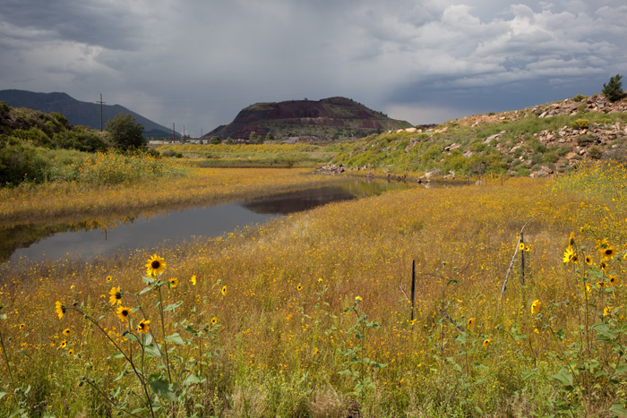
Our walk on 6 June will start from the Picture Canyon Parking lot down to the Rio de Flag and then turn right on the FUTS route through the Wildcat Reach. This will be an out and back 2 mile walk. Jack Welch, well known and beloved leader of walks in the Flagstaff area and advocate for the Rio de Flag. He will take us into an area that he has long thought should be part of the Picture Canyon Open Space.
This is an excerpt from his July 17, 2017 Arizona Daily Sun column:
The section of the Rio de Flag east of Home Depot at the Flagstaff Mall and north of the railroad tracks has in recent years been called the Wildcat Reach. That segment of our ephemeral little river can be seen from East Route 66 down the slope from the ADOT yard.Countless years of abuse and maltreatment had that unit of the Rio looking more like an industrial dumping ground than a viable feature of a river system. Filled with trash and the coloration left from a long-abandoned paintball court, it seemed to be a permanent blemish on the body of Flagstaff.Not everybody, however, viewed the Wildcat Reach as irredeemable. Some could look past the highly damaged landscape and see an important city resource, a vital link into Picture Canyon and the possibility of a sustainable wetland.In 2008 the Flagstaff Stream Team did a survey and categorized the Wildcat Reach as one of the city locations most in need of restoration. Led by David McKee at a Make a Difference Day in 2011, a large group of citizen volunteers removed 8.2 tons of debris from the Wildcat Reach, including refrigerators, car parts and huge chunks of concrete.The unsightly paintball battlefield was completely eradicated. That space alone entailed the removal of 67 truck tires, many discarded couches and a dumpster full of invasive weeds.The Wildcat Reach of the Rio de Flag is located between East Route 66 and the Flagstaff El Paso Road. The section near East Route 66 is state trust land, then comes a segment of city owned property. The Coconino County parcel starts where the city land ends and follows a section of already constructed county trail to an open gate. From that point to the Flagstaff El Paso Road is city-owned land.Confused? Don’t be, because the county recently installed the easily identified section of trail between the two undeveloped pieces of city property and the State Trust Land still to be purchased. Once completed, the FUTS will connect East Route 66 through Wildcat Reach into the Picture Canyon Natural and Cultural Preserve.Won’t it be wonderful when the FUTS is connected all the way through the Wildcat Reach and we can traverse Picture Canyon on a completed urban trail? And why not combine the Wildcat Reach and Picture Canyon into one city/county sponsored preserve?
Join us on Thursday, June 6 to see the changes, hopes and plans for the future of the Wildcat Reach.